Tuesday, September 29, 2009
We have been out of the area for about two months. Good to get back. The leaves are changing and it is so beautiful to see. We have a lot of visitors to the area and they are enjoying themselves with hikes and sightseeing tours. If you have never been here in the fall you should make it a point to come and see nature at it's best.
Monday, July 20, 2009
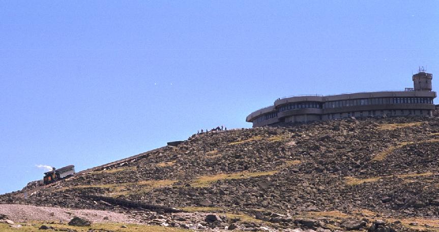
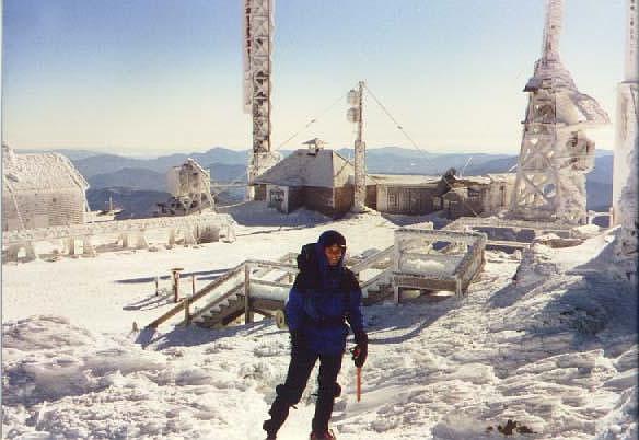
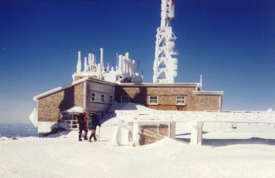
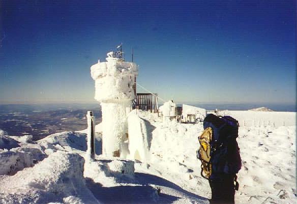
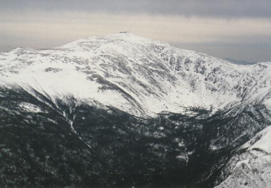
Mt. Washington - 6288'
The highest mountain in the northeast, Washington was first climbed in 1642 by Darby Field and two native guides. There is a cog railroad running to the summit from the west and an auto road from the east. The highest surface wind ever recorded on earth was on the summit of Mt Washington, 231 MPH on April 12, 1934.
The summit is covered with several buildings, including the Sherman Adams Visitor's Center, TV and radio antennas, the Yankee Building and the Mt Washington Observatory. It is known for having the worst weather in the world, especially bad in the winter. There are many monuments to hikers who've died on the mountain, including this one to Lizzie Bourne. During the summer months, there is a cafeteria, museum, payphone, gift shop, and even a post office in operation. In winter, there is no access to any of the buildings. The Obs is staffed year-round by weather observers.
The summit is covered with several buildings, including the Sherman Adams Visitor's Center, TV and radio antennas, the Yankee Building and the Mt Washington Observatory. It is known for having the worst weather in the world, especially bad in the winter. There are many monuments to hikers who've died on the mountain, including this one to Lizzie Bourne. During the summer months, there is a cafeteria, museum, payphone, gift shop, and even a post office in operation. In winter, there is no access to any of the buildings. The Obs is staffed year-round by weather observers.
Thursday, July 16, 2009
Boulder Loop Trail
White Mountain National Forest - Boulder Loop Trail
The Boulder Loop Trail is located off the Kancamgus Highway near the Covered Bridge Campground. The three-mile-long trail passes through broad-leafed and evergreen forests to reach its highest point at ledges 1000 feet above the Passaconaway Valley. Allow about 1 to 1= hours for the walk up and one hour for the downward leg. Along the trail are 18 stops which are numbered and keyed to the guide below. Yellow blazes mark the trail route.
Sturdy footwear should be worn on this trail. Hiking boots are recommended. Please stay on the trail and use caution at all times, particularly near the ledges.
Over 50,000 years ago, the Wisconsin Ice Sheet gathered in Canada and grew southward. Eventually it covered every mountain and valley in New Hampshire. On melting, the ice picked up frozen soil and broken pieces of rock. This glacial material acted like a giant piece of sandpaper being dragged across the land surface. The last of the ice melted away some 10,000 years ago.
As you walk this trail you will see the effects and results of glaciers. The scoured and scratched granite was probably covered by soil before the grinding ice dragged the surface material away and exposed the ancient bedrock.
Wednesday, July 15, 2009
The Basin-Cascades Trail
Altitude gain: 600 feet to Rocky Glen Falls (altitude 2000 feet).
Difficulty: EASY to Kinsman Falls; MODERATE thereafter.
If there were a delight meter for measuring the splendor of waterfalls, its reading for the Basin would be surprisingly low, considering the spot's great popularity. This large pothole pool set in a riverbed sculpture of polished Conway granite is a fascinating natural feature, to be sure, but not much of a waterfall. Most visitors gaze at the swirling currents for a few minutes, snap a photo, and then tramp back to their cars. Adventurers who leave the crowds behind and forge up the Basin-Cascades Trail, however, quickly find their delight meter swinging high into the Lovely zone Dr. William Prime, who was known as America's Izaak Walton for his popular nineteenth- century book I Go A-Fishing, called Cascade Brook "the finest brook in America for scenery as well as for trout." Cascade Brook is a delight not only in terms of lovely views. The cascades and waterfalls that extend for a mile along the brook are also great fun to explore, offering a mixture of broad ledges, cool glens, and tempting pools. If you bring any rambunctious kids along it will be hard to hold them back! They'll find the urge to scamper up the ledges nearly irresistible. And on a warm summer day they might "accidentally" get pretty wet investigating the clear pools. A visit to the falls can be combined with a hike to Lonesome Lake, which occupies a picturesque basin beneath the high bluffs of Cannon Mountain, 1000 feet above the floor of Franconia Notch. Best of all would be to combine the waterfall hike with an overnight stay at the Lonesome Lake AMC hut. The hut offers visitors hearty home cooking, fine hospitality, and a perfect
view of evening alpenglow shimmering on the cliffs of Franconia Ridge across the notch.
Tuesday, July 14, 2009
UPPER AMMONOOSUC FALLS
On old Cherry Mountain Road, off Rt. 302 between Cog RR and Fabyans. Take an immediate left (before railroad tracks) and park in the area at the end of this paved road. Walk down the dirt road at the end of the parking lot (about a .1 mile hike).
Saturday, July 11, 2009
National Park.Com
National Park Overview:
Located north of New Hampshire's central plateau, lies the White Mountains National Forest, cloaked with forests and laced with streams. Among the ranges and ridges are the highest mountains in the Northeast, the Presidential Range, which culminate in the bare granite summit of 6,288-foot Mount Washington, Mounts Adams, Jefferson, Monroe and Madison also exceed 5,000 feet in elevation. The Appalachian Trail in New Hampshire runs mainly through the White Mountains, including a section along the Presidential Ridge that is the longest section of the trail above the treeline
Located north of New Hampshire's central plateau, lies the White Mountains National Forest, cloaked with forests and laced with streams. Among the ranges and ridges are the highest mountains in the Northeast, the Presidential Range, which culminate in the bare granite summit of 6,288-foot Mount Washington, Mounts Adams, Jefferson, Monroe and Madison also exceed 5,000 feet in elevation. The Appalachian Trail in New Hampshire runs mainly through the White Mountains, including a section along the Presidential Ridge that is the longest section of the trail above the treeline
Wednesday, July 8, 2009
ARETHUSA FALLS
ARETHUSA FALLS:
1½ mile path south of Willey House site off Rt. 302 in Crawford Notch. Approx. 200 ft. high. Arethusa may be your destination, but Bemis Brook and Coliseum Falls are a bonus: these two are along the way to Arethusa. They are an easy .5 mile hike in, while Arethusa is 1.3 miles in on a hike of moderate difficulty. Arethusa is best viewed from below. Do not try rock scrambling: the rocks are unsafe. If you wish to swim, choose spots downstream1½ mile path south of Willey House site off Rt. 302 in Crawford Notch. Approx. 200 ft. high.
1½ mile path south of Willey House site off Rt. 302 in Crawford Notch. Approx. 200 ft. high. Arethusa may be your destination, but Bemis Brook and Coliseum Falls are a bonus: these two are along the way to Arethusa. They are an easy .5 mile hike in, while Arethusa is 1.3 miles in on a hike of moderate difficulty. Arethusa is best viewed from below. Do not try rock scrambling: the rocks are unsafe. If you wish to swim, choose spots downstream1½ mile path south of Willey House site off Rt. 302 in Crawford Notch. Approx. 200 ft. high.
Tuesday, July 7, 2009
Hiking Safely.
Hiking Safely.
Know where you are going and let someone know where you are going. Check the weather and dress accordingly. If you are hiking in unfamiliar terrain, always prepare for an overnight stay. Yes, just pack for an emergency. Be safe not sorry.
What to bring. It varies but there are some items you should consider.
Plenty of water ( 3 liters per person per day)
Flashlight (plus spare batteries and bulbs)
Rain/wind/cold weather wear (can be very lightweight)
Food. Think about it. A condensed package of energy food
Whistle
Watch
First-Aid kit
Compass/map of area
I. Knife
Fire starters
Cell phone (hopefully there is coverage) Save the charge and keep it off.
If hiking is new to you, please consider hiking with a hiking group at first to gain the experience needed to survive should you get lost. There are so many individuals who have lost their life because they thought that if they just stay on the trail there would not be a problem. Anytime you are out of your enviroment your survival always will depend on your knowledge and experience. Acquire that knowledge and experience.
Here is the following story, submitted by a victim of a search and rescue effort, illustrates the need to be aware of hazards in the outdoors. His actions not only endangered himself but those who responded to his aid. What began as an innocent day hike, to view one of Yosemite's natural wonders, ended in a traumatic experience at the edge of a waterfall.
Listen to his story:A bead of sweat rolls off the edge of my nose as I sit and rest, listening to the sounds of the most magnificent forms of Mother Nature I have ever seen. With great anticipation, I arrive and continue my climb trying to imagine what beauty lies ahead. With each step, my excitement excels. I am determined to reach the top.My strides stretch as I envision a most spectacular view at Upper Yosemite Falls, my temporary destination. I decide to take another short rest. I sit under a tree, enjoying its shade, and my attention becomes drawn to a powerful hum. A brightened smile appears when I realize that I am close to reaching the top. I shake off my backpack and pull out a water bottle to quench my thirst. I sip the mountain water and simultaneously my pores open, allowing the water to exit my body.As I feel my body cool down, I watch a group of Fresno teenagers make way from the trees returning to the main trail. The leader and I exchange smiles. He asks me how would a cool misty spray feel right about now. I answer with a slight nod of the head. He explains that he is a regular traveler in this park and behind that tree is a narrow path that leads to the base of the upper falls. He goes on to say that it is a great place to cool off. With a strong wind creating a cool, misty atmosphere, it seems like an innocent plan. I think to myself, "I have been hiking for a few hours and it's almost noon. Why not take a break?" I gather my things and head down the narrow path.A thunderous roar deafens my ears as I approach the sight of the waterfall. Standing next to a boulder, I set my bag down and let the cool mist saturate my skin. I couldn't believe my eyes. I felt so small standing in the presence of Yosemite Falls. I almost felt as if I were trespassing by invading Mother Nature's territory. Suddenly I felt very cold. I knew it was time to get on my way, but I thought a picture would capture this moment. The camera snaps, and I walk back to my bag.My first step proves the path was prone for disaster. My foot lost its traction on the wet, slimy rock as I fall on all fours. On my hands and knees I slowly slide down a long stretch of wet, algae-covered rock. My mind cannot even respond. My speed quickly increases. My body is sliding out of control towards the base of the upper falls. Before I even let out a scream, I plunge into the roaring rapids that are heading for the lower falls of Yosemite's main attraction. My body now is part of the water, and I honestly couldn't tell you how I was feeling. I was basically waiting for the unexpected. Submerged in the water for no longer than a few seconds, I a m tossed onto a rock that was right in the middle of the waterfall. I stood praying for a rescue and thanking the Almighty that I was given a chance. For several hours in hypothermic conditions, I waited.My positive and optimistic feelings started to drift away until the rescue crew appeared. I felt somewhat relieved. Their energy awakened me and gave me anew sense of hope. Although I felt relief, I wondered what they could do in these conditions. I thought the rescue would require a miracle. I tried to keep my eyes open watching them prepare to set up equipment. I regretted not staying on the main trail as I tearfully watched these people risk their most precious gift for me. Their courageous efforts are the reasons why I am here right now. I cannot express enough of my heartfelt appreciation. Man has destroyed much of Mother Nature and has polluted Her sacred land. I feel that by going off the main trail, I too had invaded Mother Nature's space. Maybe my accident was Her way of telling me to back off and respect Her territory. By staying on the main trail, we all can respect Her beauty and majesty without endangering our most precious gift - life.
The victim was cited into court for creating a hazardous condition. He was found guilty by a U.S. Magistrate. His sentence was to pay restitution and submit an article to the National Park Service summarizing his experience so that others might learn.
Friday, July 3, 2009
National Forest Service
Champney Falls Trail
The trail begins at the Champney Falls
Parking Lot on the Kancamagus Highway
(Rt. 112), 10 miles west of its junction
with Route 16.
Trail distances and estimated hiking
times from trailhead:
Champney Falls Loop: 1.4 miles, 55 min.
Piper Trail: 3.2 miles, 2 hrs., 35 min.
Mt. Chocorua summit 3.8 miles, 3 hours.
Elevation Gain: 2500 feet
Trail narrative: The Champney Falls
Trail begins by the information board in
the parking area. After crossing the
footbridge over Twin Brook, the trail turns
sharply to the right. Follow the gradual
grade of an old logging road to Champney
Brook. At 1.4 miles, a loop trail will
branch off on the left to scenic Champney
and Pitcher Falls. In .3 miles the loop will
reconnect with the Champney Falls Trail,
which becomes steeper. The first set of
switchbacks is reached at 2.4 miles. At 3.0
miles the Middle Sister cutoff leads to the
Middle Sister Trail. The Champney Falls
Trail will reach a saddle and pass the
Middle Sister Trail on the left. Soon
The Champney Falls Trail ends at the junction
of the Piper Trail, which will lead you to
the summit in .06 mile.
Loop hike options:
From the summit, descend via the Beeline
Trail to the Bolles Trail. Turn right onto
the Bolles Trail and return to the parking
area where you began.
Wednesday, July 1, 2009
JUST A BEGINNER?
From "Wild Earth Adventures"
If you’re a beginner, for maximum enjoyment and safety there are some things you should know before plunging in. Hiking isn’t at all a risky businessif you know what you’re doing, but if you’re considering hiking alone or with inexperienced friends, it’s vital to know how to take care of yourself in the wilder places in all possible circumstances. Whenever there’s a news story about someone being lost in the woods, or a hiking group having to be rescued, in the vast majority of cases you’ll find that the people involved didn’t have essential gear, or lacked appropriate skills, or exercised poor judgment. You can greatly reduce the chances of ever finding yourself in such a “fix” by learning a few outdoor skills and some hiking basics.
If you’re a beginner, for maximum enjoyment and safety there are some things you should know before plunging in. Hiking isn’t at all a risky businessif you know what you’re doing, but if you’re considering hiking alone or with inexperienced friends, it’s vital to know how to take care of yourself in the wilder places in all possible circumstances. Whenever there’s a news story about someone being lost in the woods, or a hiking group having to be rescued, in the vast majority of cases you’ll find that the people involved didn’t have essential gear, or lacked appropriate skills, or exercised poor judgment. You can greatly reduce the chances of ever finding yourself in such a “fix” by learning a few outdoor skills and some hiking basics.
Friday, June 26, 2009
Boulder Loop Trail Temporaray Closure
News From The
White Mountain
National Forest
For Immediate Release: June 5, 2009
Contact: Jana Johnson (603) 447-5448 Ext. 106
White Mountain National Forest Announces Temporary Trail Closure
A portion of the popular Boulder Loop Trail, located along the Kancamagus Scenic
Byway in Conway, NH, on the north side of the Albany Covered Bridge will be
temporarily closed for trail re-construction. Beginning on Saturday, June 13 through
Wednesday, July 8 trail crews will be working to stabilize the trail and reduce erosion by
installing and/or repairing rock waterbars and rock steps.
Trail users will be asked to travel the trail in a clockwise direction up to the height of
land, and access the view points en route and at this location. However, the remainder of
the loop will be closed, requiring trail users to return by the same route. The entire loop
is 3.1 miles in length and this temporary closure will result in a distance of 2.6 miles
when traveling to the height of land and returning via the same route.
The White Mountain National Forest expects that the Boulder Loop Trail will reopen in
its entirety on Thursday, July 8 for public access.
For additional information, please contact the Saco Ranger District at (603) 447-5448,
TTY (603) 447-3121, or visit the White Mountain National Forest website at
www.fs.fed.us/r9/white
#
Tuesday, June 23, 2009
White Mountains Trail conditions
From the National Forest Service:
Come explore the White Mountain National Forest and discover the rich history of hiking and recreation Hike Safely!
Please be prepared for trail conditions that vary from well maintained to un-maintained. Whether your hiking trip will last an hour or an entire day, wear comfortable walking shoes appropriate for the season. Carry water and a good map of the area. Let someone at home know where you are going.
Please be aware of your impact on the natural environment and practice leave-no-trace hiking and camping techniques at all times. If you plan to bring your pet, keep it on a leash or under voice control to help minimize the public's concern regarding safety, sanitation, and the threat to wildlife. Please pack out any trash you may have so others may enjoy a completely natural outdoor experience.
If you travel in the spring, be careful when walking near streams. Snow runoff can increase water depth and swiftness and decrease water temperature to dangerous levels. Stay away from streambanks at this time and resist the temptation to swim or wade.
Saturday, June 13, 2009
Let's Start a hiking club.
Our White Mountains Hostel is surrounded by 750,000 acres of the National Forest. It is one of the most beautiful places on earth and everyone should enjoy nature at it's best. Since buying the hostel several years ago we have always wanted to start a hiking club. A hiking club provides individuals the inspiration to commit to a sport that is enjoyable when shared and planned with others. The enjoyment of being a club member is not only the hike outings but also the camaraderie one experiences with the gathering of good people. Planning a hike, cooking as a group and gathering and sharing life's experiences is as good as it gets. Your input would be greatly appreciated. Let us know your ideas on how to make a hiking club a reality. Also, email us at whitemountainshostel@yahoo.com or conwayhostel@yahoo.com.
Subscribe to:
Comments (Atom)
