Tuesday, September 29, 2009
We have been out of the area for about two months. Good to get back. The leaves are changing and it is so beautiful to see. We have a lot of visitors to the area and they are enjoying themselves with hikes and sightseeing tours. If you have never been here in the fall you should make it a point to come and see nature at it's best.
Monday, July 20, 2009
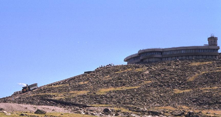
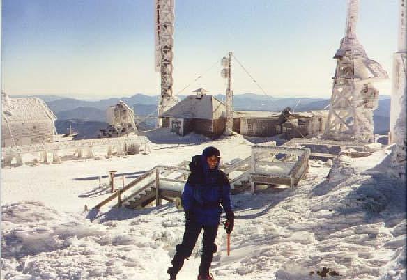
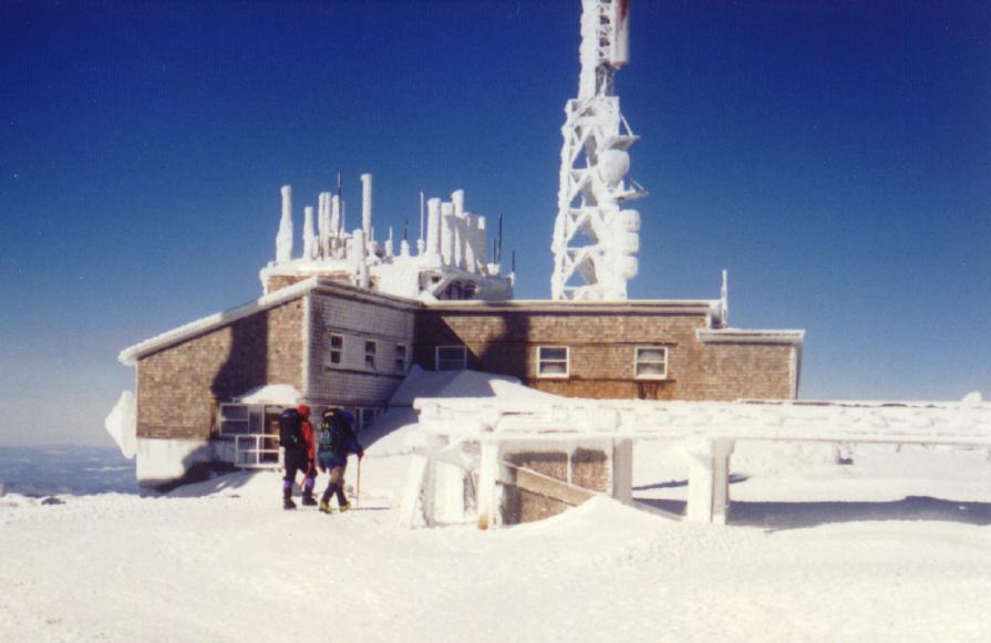
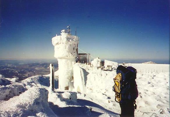
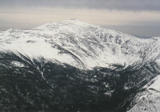
Mt. Washington - 6288'
The highest mountain in the northeast, Washington was first climbed in 1642 by Darby Field and two native guides. There is a cog railroad running to the summit from the west and an auto road from the east. The highest surface wind ever recorded on earth was on the summit of Mt Washington, 231 MPH on April 12, 1934.
The summit is covered with several buildings, including the Sherman Adams Visitor's Center, TV and radio antennas, the Yankee Building and the Mt Washington Observatory. It is known for having the worst weather in the world, especially bad in the winter. There are many monuments to hikers who've died on the mountain, including this one to Lizzie Bourne. During the summer months, there is a cafeteria, museum, payphone, gift shop, and even a post office in operation. In winter, there is no access to any of the buildings. The Obs is staffed year-round by weather observers.
The summit is covered with several buildings, including the Sherman Adams Visitor's Center, TV and radio antennas, the Yankee Building and the Mt Washington Observatory. It is known for having the worst weather in the world, especially bad in the winter. There are many monuments to hikers who've died on the mountain, including this one to Lizzie Bourne. During the summer months, there is a cafeteria, museum, payphone, gift shop, and even a post office in operation. In winter, there is no access to any of the buildings. The Obs is staffed year-round by weather observers.
Thursday, July 16, 2009
Boulder Loop Trail
White Mountain National Forest - Boulder Loop Trail
The Boulder Loop Trail is located off the Kancamgus Highway near the Covered Bridge Campground. The three-mile-long trail passes through broad-leafed and evergreen forests to reach its highest point at ledges 1000 feet above the Passaconaway Valley. Allow about 1 to 1= hours for the walk up and one hour for the downward leg. Along the trail are 18 stops which are numbered and keyed to the guide below. Yellow blazes mark the trail route.
Sturdy footwear should be worn on this trail. Hiking boots are recommended. Please stay on the trail and use caution at all times, particularly near the ledges.
Over 50,000 years ago, the Wisconsin Ice Sheet gathered in Canada and grew southward. Eventually it covered every mountain and valley in New Hampshire. On melting, the ice picked up frozen soil and broken pieces of rock. This glacial material acted like a giant piece of sandpaper being dragged across the land surface. The last of the ice melted away some 10,000 years ago.
As you walk this trail you will see the effects and results of glaciers. The scoured and scratched granite was probably covered by soil before the grinding ice dragged the surface material away and exposed the ancient bedrock.
Wednesday, July 15, 2009
The Basin-Cascades Trail
Altitude gain: 600 feet to Rocky Glen Falls (altitude 2000 feet).
Difficulty: EASY to Kinsman Falls; MODERATE thereafter.
If there were a delight meter for measuring the splendor of waterfalls, its reading for the Basin would be surprisingly low, considering the spot's great popularity. This large pothole pool set in a riverbed sculpture of polished Conway granite is a fascinating natural feature, to be sure, but not much of a waterfall. Most visitors gaze at the swirling currents for a few minutes, snap a photo, and then tramp back to their cars. Adventurers who leave the crowds behind and forge up the Basin-Cascades Trail, however, quickly find their delight meter swinging high into the Lovely zone Dr. William Prime, who was known as America's Izaak Walton for his popular nineteenth- century book I Go A-Fishing, called Cascade Brook "the finest brook in America for scenery as well as for trout." Cascade Brook is a delight not only in terms of lovely views. The cascades and waterfalls that extend for a mile along the brook are also great fun to explore, offering a mixture of broad ledges, cool glens, and tempting pools. If you bring any rambunctious kids along it will be hard to hold them back! They'll find the urge to scamper up the ledges nearly irresistible. And on a warm summer day they might "accidentally" get pretty wet investigating the clear pools. A visit to the falls can be combined with a hike to Lonesome Lake, which occupies a picturesque basin beneath the high bluffs of Cannon Mountain, 1000 feet above the floor of Franconia Notch. Best of all would be to combine the waterfall hike with an overnight stay at the Lonesome Lake AMC hut. The hut offers visitors hearty home cooking, fine hospitality, and a perfect
view of evening alpenglow shimmering on the cliffs of Franconia Ridge across the notch.
Tuesday, July 14, 2009
UPPER AMMONOOSUC FALLS
On old Cherry Mountain Road, off Rt. 302 between Cog RR and Fabyans. Take an immediate left (before railroad tracks) and park in the area at the end of this paved road. Walk down the dirt road at the end of the parking lot (about a .1 mile hike).
Saturday, July 11, 2009
National Park.Com
National Park Overview:
Located north of New Hampshire's central plateau, lies the White Mountains National Forest, cloaked with forests and laced with streams. Among the ranges and ridges are the highest mountains in the Northeast, the Presidential Range, which culminate in the bare granite summit of 6,288-foot Mount Washington, Mounts Adams, Jefferson, Monroe and Madison also exceed 5,000 feet in elevation. The Appalachian Trail in New Hampshire runs mainly through the White Mountains, including a section along the Presidential Ridge that is the longest section of the trail above the treeline
Located north of New Hampshire's central plateau, lies the White Mountains National Forest, cloaked with forests and laced with streams. Among the ranges and ridges are the highest mountains in the Northeast, the Presidential Range, which culminate in the bare granite summit of 6,288-foot Mount Washington, Mounts Adams, Jefferson, Monroe and Madison also exceed 5,000 feet in elevation. The Appalachian Trail in New Hampshire runs mainly through the White Mountains, including a section along the Presidential Ridge that is the longest section of the trail above the treeline
Wednesday, July 8, 2009
ARETHUSA FALLS
ARETHUSA FALLS:
1½ mile path south of Willey House site off Rt. 302 in Crawford Notch. Approx. 200 ft. high. Arethusa may be your destination, but Bemis Brook and Coliseum Falls are a bonus: these two are along the way to Arethusa. They are an easy .5 mile hike in, while Arethusa is 1.3 miles in on a hike of moderate difficulty. Arethusa is best viewed from below. Do not try rock scrambling: the rocks are unsafe. If you wish to swim, choose spots downstream1½ mile path south of Willey House site off Rt. 302 in Crawford Notch. Approx. 200 ft. high.
1½ mile path south of Willey House site off Rt. 302 in Crawford Notch. Approx. 200 ft. high. Arethusa may be your destination, but Bemis Brook and Coliseum Falls are a bonus: these two are along the way to Arethusa. They are an easy .5 mile hike in, while Arethusa is 1.3 miles in on a hike of moderate difficulty. Arethusa is best viewed from below. Do not try rock scrambling: the rocks are unsafe. If you wish to swim, choose spots downstream1½ mile path south of Willey House site off Rt. 302 in Crawford Notch. Approx. 200 ft. high.
Subscribe to:
Comments (Atom)
